Backpack the Grand Canyon in Three Nights
I just got back from a four day, three night backpacking trip in the Grand Canyon. Four of us (an old buddy from college who did the planning, two new friends from Flagstaff, and I) backpacked the Tonto Trail from the Bright Angel trailhead to the Hermit trailhead. The trip was completely inspiring; a great way to ring in spring and a new season in the backcountry. For those of you with an itch to do the Grand Canyon, I’m going to detail for you a perfect, must-do moderate 4 day, 3 night itinerary. Pictures of this Grand Canyon trek will not do it justice.
Prep and Gear
The gear you’ll need in the Grand Canyon is similar to gear you’d need in the Sierra. Check out our backpacking checklist for a quick refresh. I’d make three adjustments. First, you can ditch the bug spray. It’s so dry, mosquitoes aren’t a problem. Second, hiking in long pants is recommended. Lots of cactus and thorny plants crop out from the trail. You’ll want to make sure your shins have some protection. Last, it’s important to plan your water requirements out for each day, bring extra bladders/containers for water storage, and read up or ask a ranger about water availability before hitting the trail. Water can be scarce, and one of the water sources you’ll cross is contaminated with Uranium.
Grand Canyon Day 1
We started on the main Bright Angel trail. The trailhead is near the visitor center (elevation 6,900′). For the first 5 miles, we were on the same trail that mules and tourist descend. Try and get a jump start before 8:30am so you can beat the mules out of the gate; we didn’t quite make it. The first hours are a steep, direct descent. For me, it was still exhilarating since it was my first time in the canyon. After 5 miles we had descended about 3,000′. This brought us to Indian Garden. Here you can stock-up on fresh water for the rest of the day (and the first half of tomorrow). Clean water flows from a spigot near campsites on the west side of the trail.
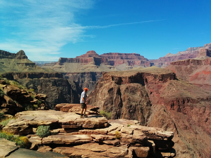
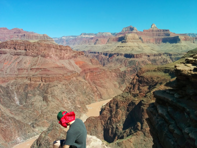
Upon leaving Indian Garden, you’ll head west on the Tonto Trail. The “Tonto Trail” as I’ve learned, is the name given to the ~95 miles of trail that follows the Tonto Platform. It’s kind of like an inner plateau within the Grand Canyon. When I was on the Tonto Trail, I felt I had the best perspective for the spectacular grandness of the Canyon. The trail loosely parallels the Colorado River and offers incredible sheer cliff views into the inner gorge where the river flows some 1,000′ below. When you pick your head up while heading west, you’ll find 3,000 foot cliffs that reach to the rim, and a panorama of canyon that engulfs you with new grandeur at every turn.
Less than a mile into the Tonto Trail there’s a fork with a trail that jets out to Panorama Point. Drop your pack at that junction, grab a bottle of water and a snack, and hike the mile or so out to Panorama Point. It’ll give you your first view of the river. It’s pretty awesome.
Retrace your steps, pick up your pack, and continue on to Horn Creek, about 2 miles ahead. There is water at Horn Creek, but it’s contaminated with trace amounts of Uranium from an old mine up the canyon (so don’t drink it). Use the fresh water you packed in from Indian Garden.
Horn Creek is one of the creeks tucked within the many folds and tributary canyons of the Grand Canyon. Our stay at Horn Creek was super windy. I’m not sure if this is typical, or just our luck. The campsite did, however, have a huge rock which was great to lie out on and star gaze. One unique thing about camping in the canyon is that even on evenings when the moon is full, the tall canyon walls shield the light just long enough each night to provide an amazing display of stars.
Grand Canyon Day 2
On day two we woke up and realized we had used more water than we had planned, so between the four of us we re-balanced and rationed our water supply so that we could make it to the next water source at Monument Creek, about 8.5 miles away.
Those 8.5 miles on the Tonto Trail are pretty moderate: rolling uphill, awesome vista – rolling down hill, awesome tributary/side canyon. This pattern replicates itself about three times, pulling you past Salt Creek at about 4.5 miles (don’t drink the water here either), until you reach Monument Creek.
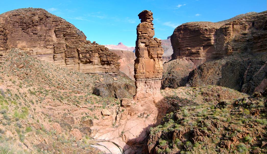
When we dropped into Monument Creek, we saw a small trickle of water running. There was just enough water flow to filter. We replenished our water carriers which were running low. Across the creek were a few campsites. We continued up the trail maybe a 100 yards on until we came to the Monument Creek trail junction that headed down to the Colorado River and Granite Rapids campsite. We rested not too far from that junction, just before dropping down onto the floor of the gorge, and below a monumental free-standing 500 foot pillar which lends this creek its name.
This was one of my favorite places on this trail. You’re situated below the Tonto ledge, above the gorge floor, and inside an awe-inspiring, cavernous, bowl shaped canyon with this giant freak of nature rock formation jetting high into the air only 50 feet away in the center of it all. Wow… getting goosebumps again.
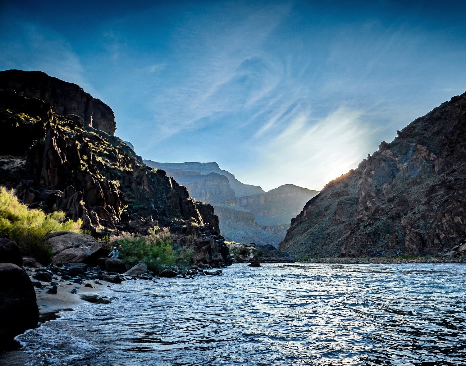
After a long lunch, we continued down a relatively easy, winding path along the creek bed for a mile and a half until we reached the Colorado river. The water in Monument Creek actually disappeared until the last quarter mile or so, when it began to flow again with greater strength.
Approaching Granite Rapids, we were told the rafters typically camp to the east of Monument Creek, while the hikers camp to the west. We followed the trail markers up to the west and onto a beach. We were told by a ranger there was no shade on the west side of the beach. That wasn’t true. If you walk 50 yards past the obvious campsites, you’ll find the last campsite on the strip butts up against some towering rocks to the west, providing good cover from the afternoon sun.
The river seemed like a happening place. There were rafters floating by most of the afternoon. One interesting note is that the park service requests that you pee into the river when camping on the banks. At first, this seemed counter intuitive. Apparently the best solution for pollution, in this instance, is dilution.
Grand Canyon Day 3
Day three was a relatively easy day for us. We hiked 1.5 miles back up Monument Creek to the junction with the Tonto Trail, and hopped back on it heading west. I should qualify easy. Within the first 2.5 miles there is a 1000+ foot ascent which pulls you out of the gorge and back onto the Tonto Platform.
Following the trail another two miles brought us to a junction with the Hermit trail. The Hermit trail leads back up to the South Rim. We continued west another 1.5 miles, past a junction for Hermit Rapids, past what appeared to be some old stables, and then down into a small gorge that was home to Hermit Creek.
This appears to be a popular campsite. There was a strong flowing creek, a small swimming hole, plenty of campsites, and company to fill them. We got into camp early, and took the afternoon to regroup, recharge and explore up and down the gorge, which was pretty awesome.
Grand Canyon Day 4
This was by far my favorite day in the Canyon. It may have had something to do with the sense of accomplishment that comes from making it back to the rim. But the hike itself was absolutely beautiful. Words and pictures won’t do it justice.
We got an early before sun-up start to begin the 8.5 mile 4,000 foot ascent to the Hermit trailhead. It took about 4.5-5 hours altogether.
The first 1.5 miles we covered in about thirty minutes, retracing our steps back to the Hermit trail junction. Then, for the next 3 hours, we climbed. Up. We had the mountain to ourselves. The trail hugged the eastern wall of this inner canyon. The wall shaded us from the sunrise which now lit up the rim of the Grand Canyon like a golden crown. The trail passed through multiple layers of canyon with amazing colors; through rocky nooks and crags; parts of the trail had short scrambles across chaotic jumbles of rocks washed down or fallen from gullies above. The other three guys were hauling tail and the workout was invigorating. There was plenty of time, and reason, to dig deep and think about family, friends, and work which we’d be re-encountering just hours ahead. For those three hours, everything was in sync, everything felt right.
Then the sun came up. And the trail was exposed. And it was hot. And still uphill.
The last 45 minutes to an hour was our last push up to the top of the rim over what appeared to be an incredibly expensive and labor intensive trail to build. It seemed like a golden staircase, with parts of trail surfaced with large hand-fitted golden colored rock slabs that created a smooth walking surface. With a little reading post trek, I learned that the Hermit trail was “the trail” in its heyday of the early 1900s, and part of the trail underwent remarkable labor-intensive paving to make it user friendly. It’s an incredible sight.
Finally when you make it back to the rim, hike about 100 yards down the road to catch a tourist shuttle bus that will take you on a 30 minute ride back to the visitor center and your starting point. Find the cafeteria and grub out.
Summary with numbers
| Day 1 |
|---|
| Bright Angel trailhead (6,860 ft) to Indian Garden (3,800 ft): 4.8 mi |
| Out and back to Panorama Point: 2 mi |
| Indian Garden (3,800 ft) to Horn Creek (3,550 ft): 2.5 mi |
| Total mileage: 9.3 mi |
| Day 2 |
| Horn Creek (3,550 ft) to Monument Creek (2,995 ft): 8.2 mi |
| Monument Creek (2,995 ft) to Granite Rapids (2,330 ft): 1.6 mi |
| Total mileage: 9.8 mi |
| Day 3 |
| Granite Rapids (2,330 ft) to Monument Creek (2,995 ft) : 1.6 mi |
| Monument Creek (2,995 ft) to Hermit Creek (2,900 ft): 3.5 mi |
| Total mileage: 5.1 mi |
| Day 4 |
| Hermit Creek, (2,900 ft) to Hermit trailhead (6,640 ft): 8.2 mi |
| Total mileage: 8.2 mi |
Notes and resources
We hiked the trail in mid-March. In my opinion, this is the Goldilocks time of year. It wasn’t too hot, it wasn’t too cold, and the desert blossoms on the trail were just right. I can’t imagine doing this trail in July, but if YOU can, please plan appropriately.
If you’re hooked with interest, be smart and read up on the trail. Here are some free resources you can consult:
http://www.nps.gov/grca/planyourvisit/upload/Tonto-Bright_Angel_to_Hermit.pdf
http://www.nps.gov/grca/planyourvisit/upload/Hermit_Trail.pdf
http://www.nps.gov/grca/planyourvisit/backcountry-permit.htm
If you have questions, shoot me an email or contact us on facebook/twitter.
Happy to help!